Big Dry Creek Map – Gila Wilderness, New Mexico
Our
extensive exploring has exposed many unknown wonders in the high Mogollon Range
of the Gila Wilderness, New Mexico. We
now wish to share all of our findings with you via this map below. This is the ONLY map of its kind on
earth. Please enjoy it and share it with
ANY and ALL.
Also of special interest is a discovery we have
recently stumbled onto. Check this
out: For years we have heard about a
“phantom” trail repairman in the Gila Wilderness, who has long been repairing
and maintaining trails that the feds have discontinued and abandoned. Nate Bartnick and I
caught him...!!! RED HANDED...!!!
We caught
him with his tools “in hand” repairing his favorite trail: Rain Creek Divide
Trail.
Gasp...!!!
Should we “NUKE” him…???? ...or
just scold him. Maybe better yet, turn
him over to the “feds” to prosecute...for trespass and vandalism...!!!
Quite rather... we appreciate him. He wishes to remain anonymous... But WOW...
he is doing a gigantic public service...!!!
He has faithfully corrected the many mistakes on USGS Topos. At 75 years
of age, he has correctly GPS’ed trails, springs and
count-less other existing features... into their correct locations on his
maps...!!! His maps are pencil &
“white-out” on USGS paper quads.
We have now made “his info” as well as our own
findings digital and public.
Right-click-save-as on this map
below to keep a copy of it for your own files. It is
the only map of its kind on earth.
Click here to view EXTRA high-rez MAP files: North
& South
Please
use this map with the corresponding pages of these other 3 websites:
http://www.dougscottart.com/hobbies/waterfalls.htm
http://www.dougscottart.com/hobbies/SlotCanyons.htm
http://www.dougscottart.com/hobbies/NMArch.htm
see photos and notes below map
Right-click-save-as
on our map below to save a file to your desktop and to print a paper hard-copy
to hold in hand on your hike
Click here to view EXTRA high-rez MAP files: North
& South
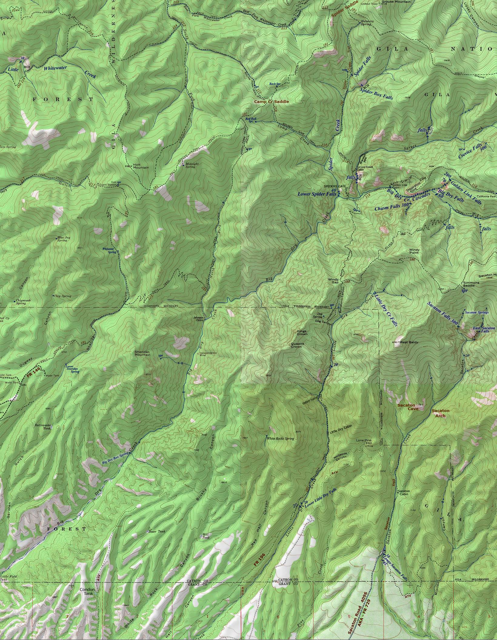
*see information webpages for
the waterfalls shown on the map above:
http://www.dougscottart.com/hobbies/waterfalls/sacatonfalls.htm
http://www.dougscottart.com/hobbies/waterfalls/bigdrycreekfalls.htm
http://www.dougscottart.com/hobbies/waterfalls/bigdrycreekcascades.htm
http://www.dougscottart.com/hobbies/waterfalls/littledrycreekfalls.htm
http://www.dougscottart.com/hobbies/waterfalls/goldenlinkfalls.htm
http://www.dougscottart.com/hobbies/waterfalls/chasmfalls.htm
http://www.dougscottart.com/hobbies/waterfalls/crevicefalls.htm
http://www.dougscottart.com/hobbies/waterfalls/spiderfalls.htm
http://www.dougscottart.com/hobbies/waterfalls/sprucecreekcascades.htm
http://www.dougscottart.com/hobbies/waterfalls/whitewater.htm
-see: Little Whitewater Falls
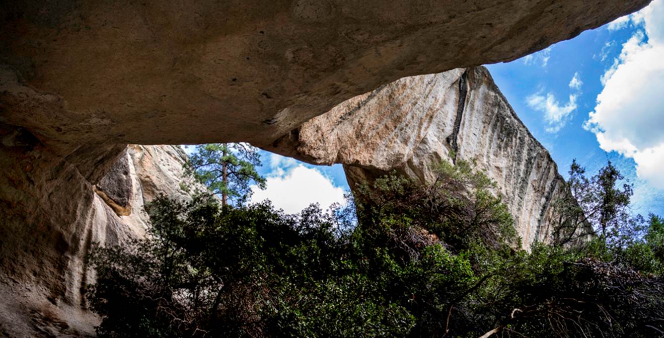
Photo below is of Sacaton
Arch, with a 75’ span, up Sacaton Canyon. Sacaton Arch was
found by Jay Hemphill in 2015.
To see more natural arches in New
Mexico click: http://www.dougscottart.com/hobbies/NMArch.htm
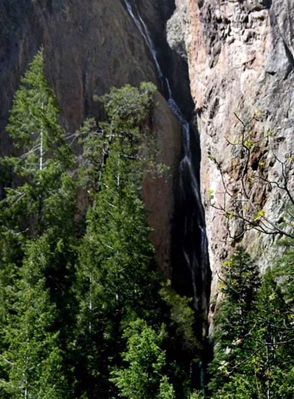
300’ high Chasm Falls is AMAZING... a
tributary of upper Big dry Creek
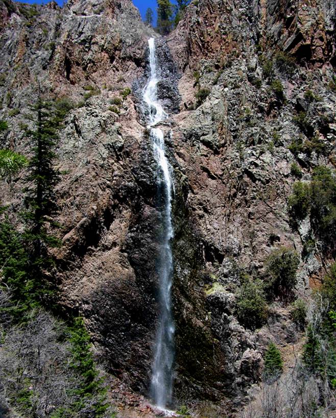
...and 300’ high Sacaton
Falls is not too far away...
Send questions and comments to dscott@themarblesculptor.com