West Fork Mogollon Falls
West Fork
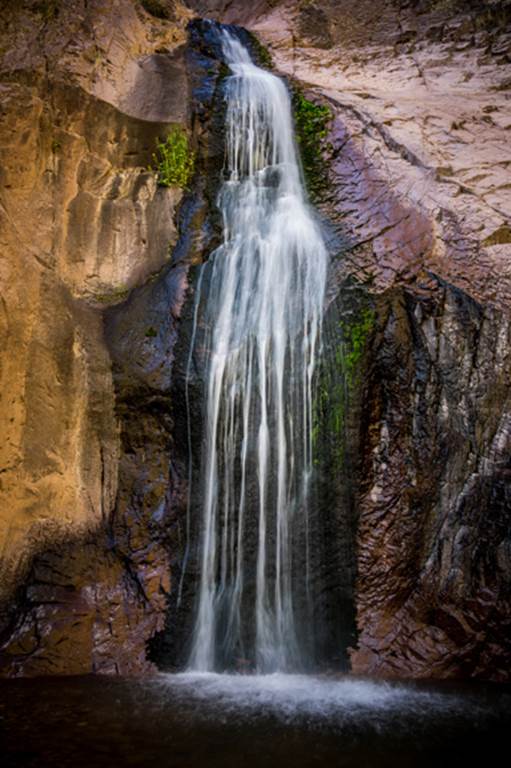
Mogollon Creek is one of New Mexico’s better waterfall streams
Upper West Fork Mogollon Creek must
have 20 or so waterfalls of 20’ high or more... However...
Most of them are within a sheer walled
narrow gorge requiring technical rock climbing/canyoneering gear to visit them.
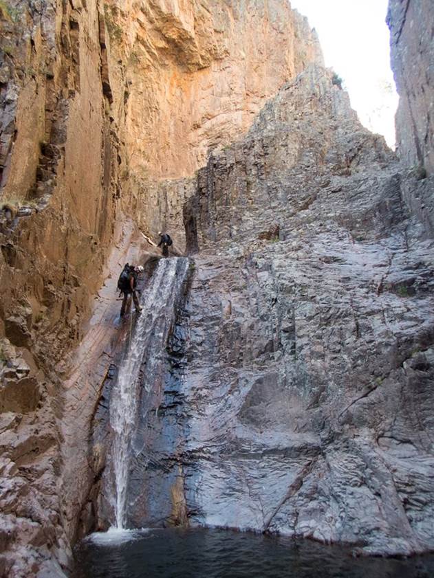
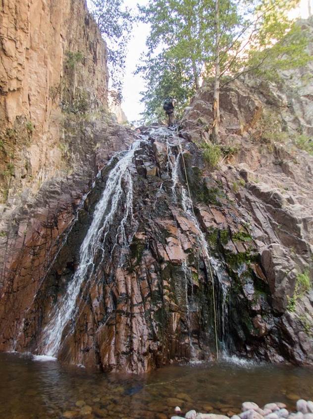
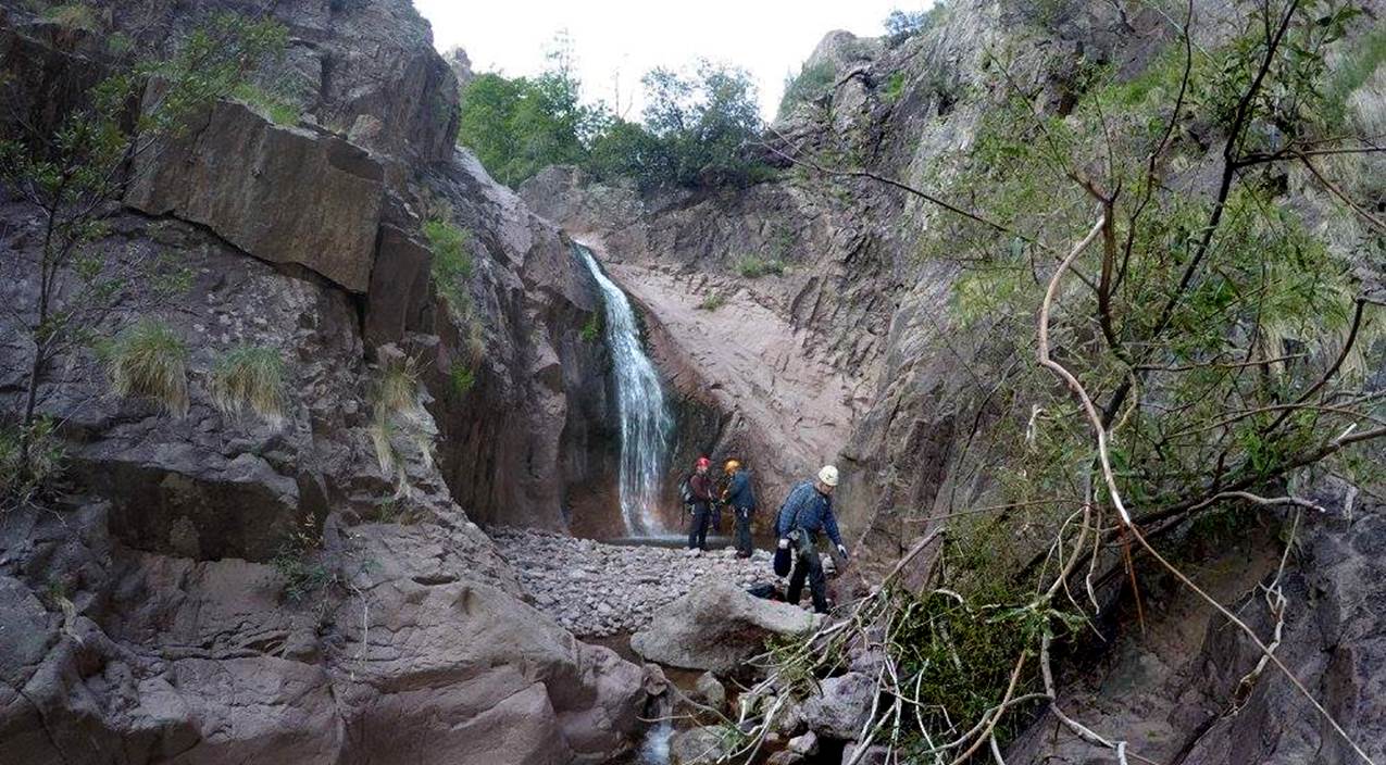
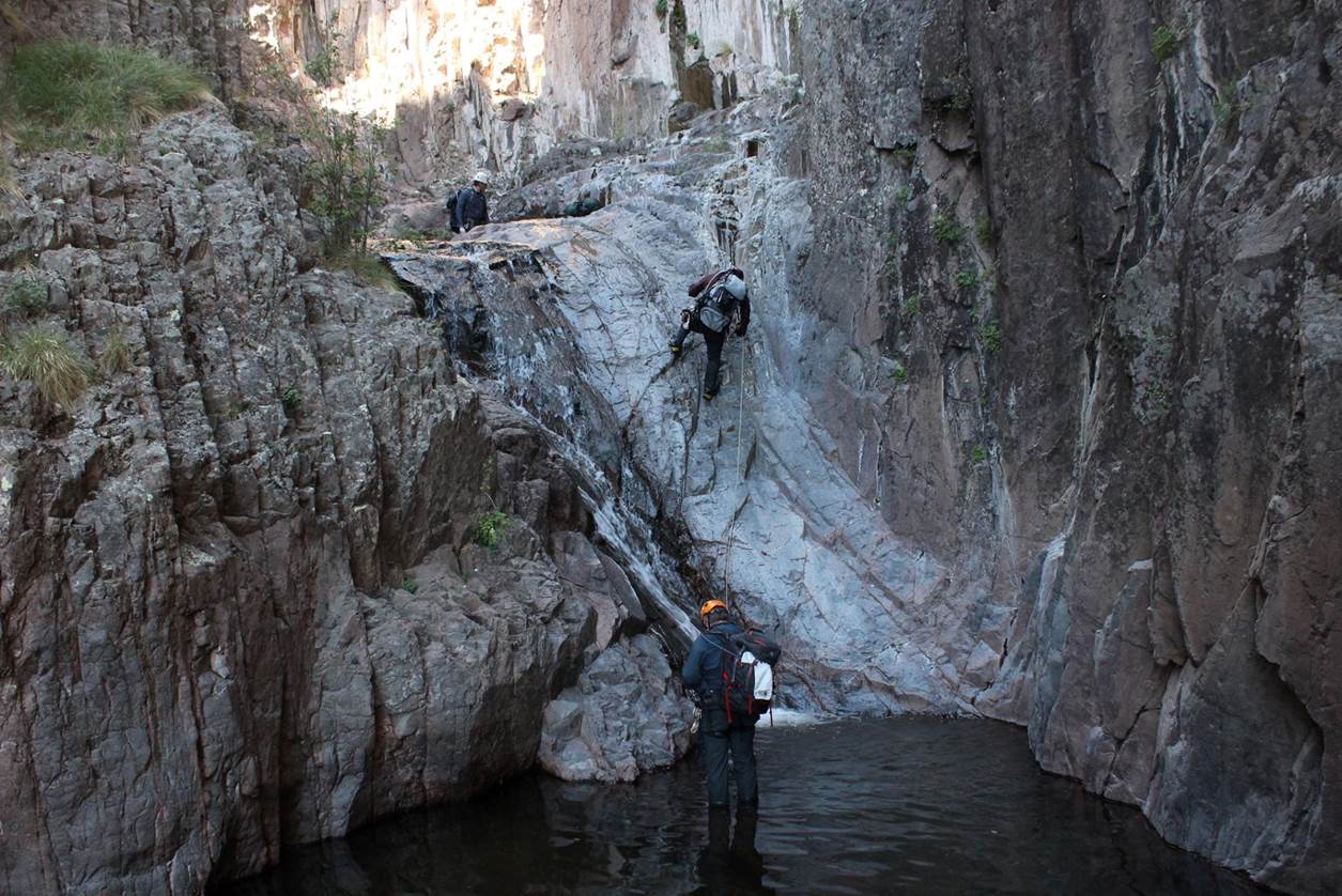
These
photos show a few of West Fork Mogollon Creek’s many wonderful waterfalls
There are several yet-to-be-explored waterfalls farther upstream
than where this team of canyoneers began their
descent... at + 7650’ elevation
The photos above were taken by Jeff Jefferies, Laurin Ashby, Dallin Durfee ...members of this Arizona team
beta facts:
name- West Fork Mogollon Creek waterfalls
height- 60’ would be about as high as this group
of West Fork Mogollon waterfalls are
elevation- waterfalls on this page are all below
7650’ elevation – there are more waterfalls yet-to-be-documented farther
upstream
GPS coordinates- ±33°16.126’N 108°37.274’W near the upstream end of this set of waterfalls and portion of slot canyon
flow- perennial
season- spring, summer and fall
accommodations- Gila Wilderness Area
ownership- Gila National Forest
access- is road 293 about 3 miles north from
Cliff, NM – then Sacaton Road 15 miles north to Rain
creek Trailhead & see map below for trail information
nearest town- Cliff and Gila are about 20 miles
south of here
fun fact- This place is about as remote as it
gets
essay bro
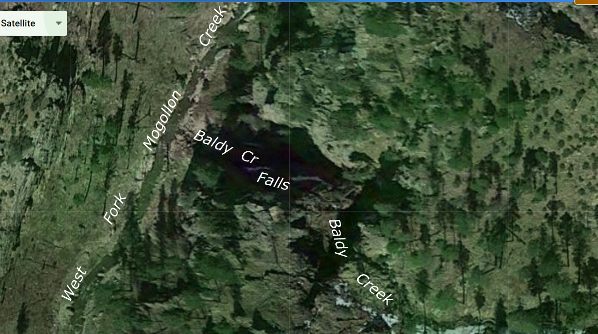
The map below shows these waterfalls that were
explored by this Arizona Canyoneering Team.
Crew members are: Dallin Durfee, Ryan Hooper,
Bret Kilgrow, Jeff Jeffries and Laurin
Ashby. Their excursion thru here was a
“first descent.” They found no evidence
(anchors, webbing, ropes or bolts) ...anything of any kind to shows that others
had been there. They explored downstream
from Baldy Creek Falls. We appreciate
them for sharing their photos and info with us.
We are impressed by the beauty of this amazing West Fork Mogollon’s
steep, narrow gorge...! ! !
We scouted this gorge previously and have
been planning a first descent for a couple years now, but on July 2, 2017 this
team led by Dallin Durfee... beat us to it...! ! ! I am a bit jealous, but glad for them and
proud of them…! ! !
However, there are still some un-explored
and yet-to-be-documented, wonderful waterfalls hiding upstream from where they
dropped in to descend this gorge. Baldy
Creek Falls, Hobo Falls and several other un-named waterfalls are yet to be
explored and documented. Do any of you
want to help us by doing that…?
?
?
The Mogollon Range holds the Gila
Mountain’s highest elevations and gives birth to the largest upper Gila River
tributaries. West Fork Mogollon Creek is
a fine trout stream draining the south slopes of the Mogollon Range. The upper West Fork Mogollon divides into
three main forks: Geronimo Creek, Hobo Creek and upper West Fork Mogollon
Creek. This south-flowing system is
easily accessible via Sacaton Road - Forest Road 147
- at the Rain Creek Trailhead (see map below).
The Mogollon Trailhead at the end of Forest
Road 916 nearby, has a sometimes impassable ford (a
bridge-less river crossing.) see map below
Some of the trails, shown by dotted lines
on our map below, no longer exist.
Forest fires along with the massive floods that followed, coupled with
discontinued maintenance, have allowed these old obsolete trails to
desist. Faint remnants of these appear
for short stretches... then vanish with no warning.
This trip deserves a two night backpack…!!!!
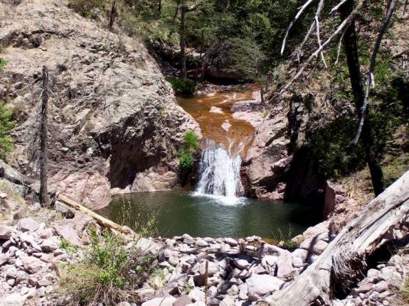
My friend Jay Hemphill sent
this image to me... he was up West Fork Mogollon a while back and shot this
image of a 30’ high West Fork waterfall found a short ways upstream from Little
Punch Bowl Falls... Thanx Jay
This appears to be very low water flow
and I recognize it to be the same waterfall as appears in the second photo
above
Jay Hemphill Photo
This next photo is a
Google Earth Image of Badly Creek Falls (see map
below)
Baldy Creek which drains Mogollon Baldy, drops
over a 120’ (est.) 2 tiered waterfall at it’s
confluence with the West Fork Mogollon Creek
GPS coordinates- ±33°16.187’N 108°37.188’W
-This falls, along with a half dozen more falls upstream, are yet to be photographed and documented.
Trail
224 hardly exists but at Little Punch Bowl Falls (shown below) know that you
are at the doorstep of many amazing, beautiful, waterfalls…!!!
Little Punch Bowl Falls is viewable from Trail 224, while all of the other falls are not.
HAPPY EXPLORING...!!!
Right-click-save-as
on our map below, to print your own “hand-held” copy for your hike
Enhanced
USGS topo map
Or click
this link to see a new updated & enlarged map: http://www.dougscottart.com/hobbies/waterfalls/WestFkMogo.htm
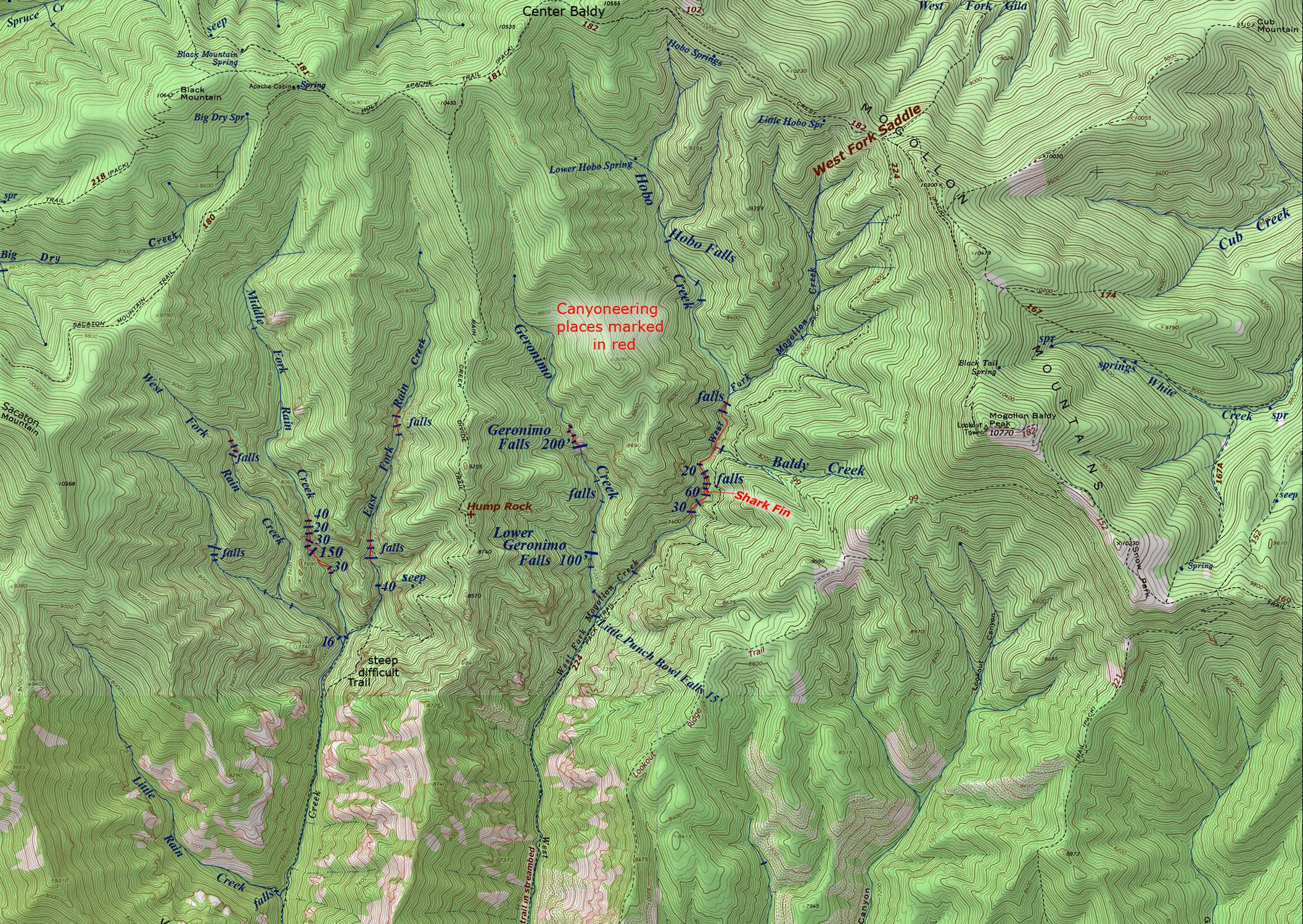
To see the
Trailhead click on this enlarged map: http://www.dougscottart.com/hobbies/waterfalls/WestFkMogo.htm
Send questions and comments to art@DougScottArt.com