Wedding Cake Canyon
See on Youtube: https://youtu.be/aCv94cxHyX0
ACA Canyon
Rating – 3A II
Experienced Canyoneers Only
requires a full
range of technical canyoneering equipment as well as multiple ropes…!!!
NEVER ENTER ANY
SLOT CANYON WHEN HEAVY RAIN IS IN THE FORECAST…!!!
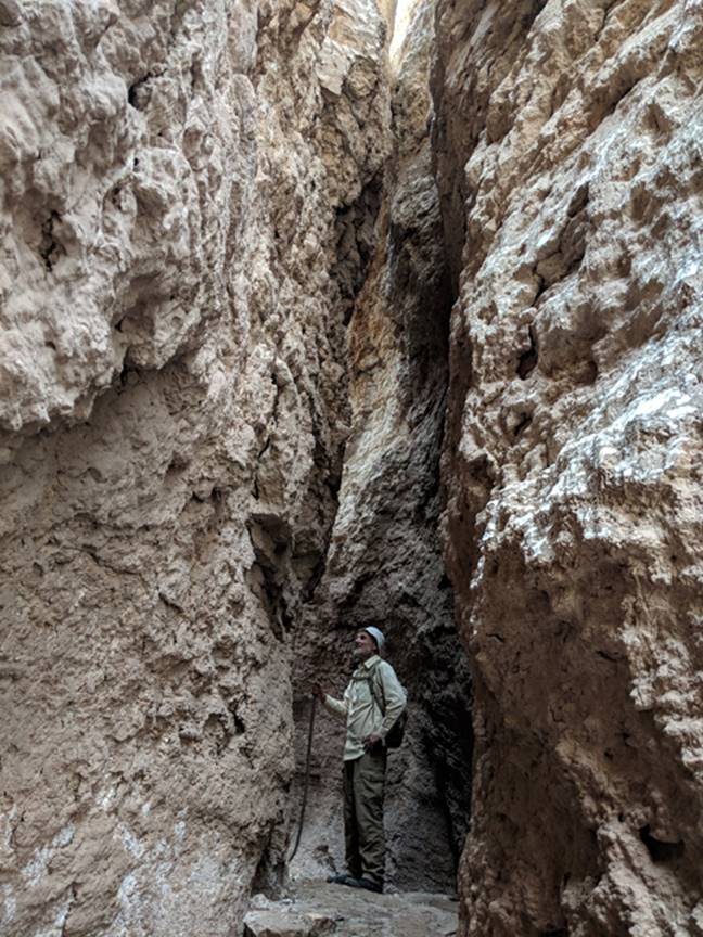
The upper section of Wedding Cake Slot
Canyon is solid alabaster forming a very narrow “slot”
Then the canyon opens up to a 100 foot
high, multi step rappel
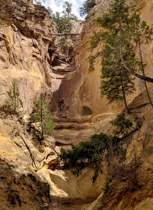
Photo below is the top of the 100’ rappel
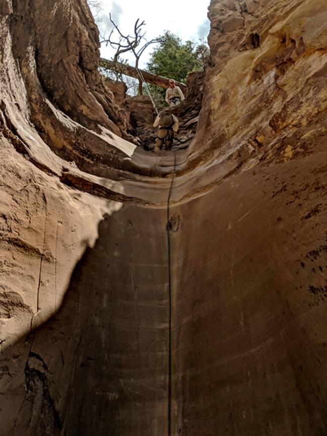
*note the use of the small branch for our
anchor, which allows our ropes to easily pull away & take with us. All 3 above photos are shot by: Steven
Anderson
Ghosting anchor allows those who follow to
see no trace of anyone having ever been here before.
beta facts:
name- Wedding Cake Canyon Slot
length of slot canyon- maybe a third of a
mile
elevation- 7250’at the top down to about
7000’at the bottom
GPS coordinates- ±36°17.690’N 106°36.407’W
flow- intermittent
season to visit- most anytime except winter
may have ice & NEVER ENTER ANY SLOT CANYON WHEN
HEAVY RAIN IS IN THE FORECAST…!!!
accommodations- nearby campground &
restrooms
ownership- Carson National Forest
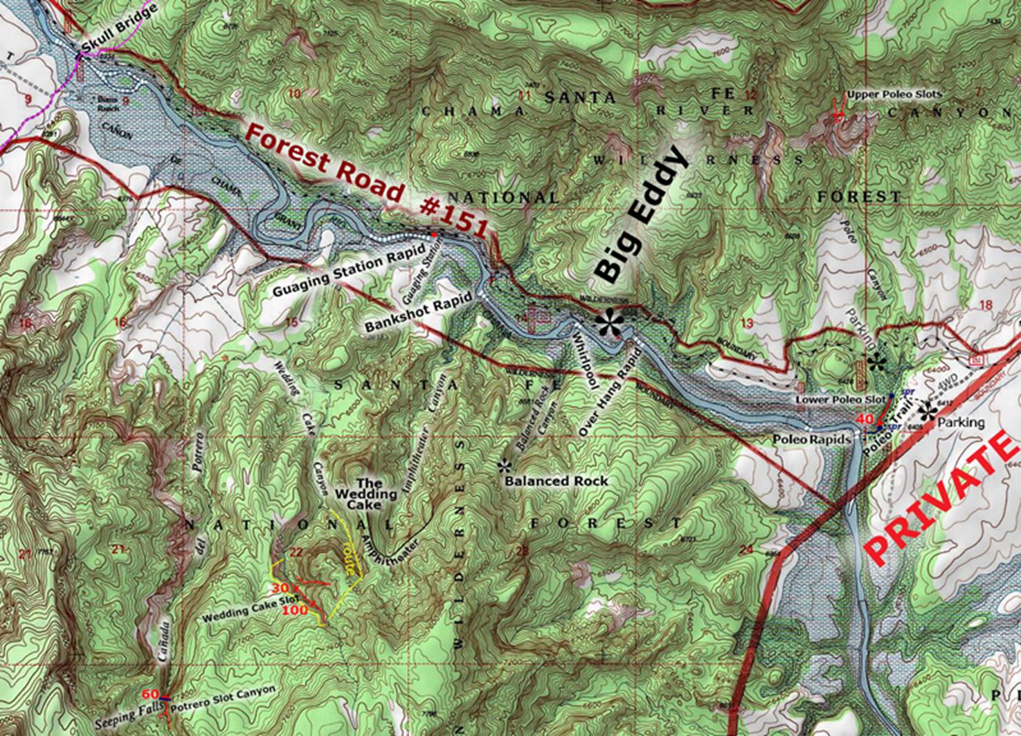
access- is from Hwy 84 and Forest Road 151…
see the map below
nearest town- Abiquiu is about 20 miles
east of here
fun fact- this is a fine slot canyon
A scenic dome looking rock
formation on the south side of the Chama River, marks your destination. Many refer to this prominence as “The Wedding
Cake ” ...and, thus Wedding Cake Canyon.
Names serve us as a reference minimizing confusion and understanding an
exact specific place.
We Parked our wheels along
Forest Road 151 at the first river-level, pull-out upstream from Gauging
Station Rapids. We then paddled canoes
across the Rio Chama, hid them in the brush and hiked up Wedding Cake Canyon. As we neared the slot, we scrambled up the
steep canyon slope to our right (west).
See the yellow “route” marked on the map below. Then followed the rim of Wedding Cake Canyon
Slot up to about 7300’ elevation, where we descended a steep slope down into
the start of the sheer-walled, alabaster, (gypsum) slot canyon. This upper-narrows portion of Wedding Cake
slot gets quite skinny, but does not require ropes until where the Todilto
Formation (gypsum) turns into Entrada Formation - Sandstone. Here- is the 100-foot-high multi-stepped
rappel. A very beautiful and fun series
of butt-sides and rope-less down scrambles leads to a sweet 30’ rappel near the
mouth of the Slot. Your anchor here,
will be on a bush, a good ways upstream from the rappel.
If you do not have watercraft
to cross the river in, and/or if the river is flowing too high to wade... Then
hike into Wedding Cake Canyon from Scull Bridge, upstream about a mile. This quite do-able and quite pleasant. Wedding Cake Slot Canyon appears to the lower
left on our map below.
see: ‘ http://www.dougscottart.com/hobbies/SlotCanyons/Gallina.htm
’ to view larger detailed maps of this entire
area
Right-click-save-as
on our map below, to print your own “hand-held” copy for your hike
Enhanced USGS topo map
The Red Lines depict
sections of “slot canyons”
Back to New Mexico
Slot Canyons
Send questions and comments to dscott@themarblesculptor.com