Cougar Canyon
ACA Canyon
Rating – 3A III
-This canyon
was first called Cañoncito de Coloures
which is too easily confused with Cañon de Coloures-
See on youtube:
https://www.youtube.com/watch?v=_6xGB4GMdug
Cougar
Canyon & it’s tributaries cannot be traversed
without technical rope work
NEVER ENTER ANY
SLOT CANYON WHEN HEAVY RAIN IS IN THE FORCAST…!!!
...our mountain lion sighting here, and a
slot canyon floor full of big-cat tracks of all sizes... has caused us to now
call this slot: Cougar Canyon
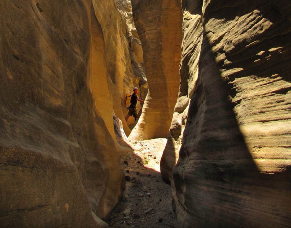
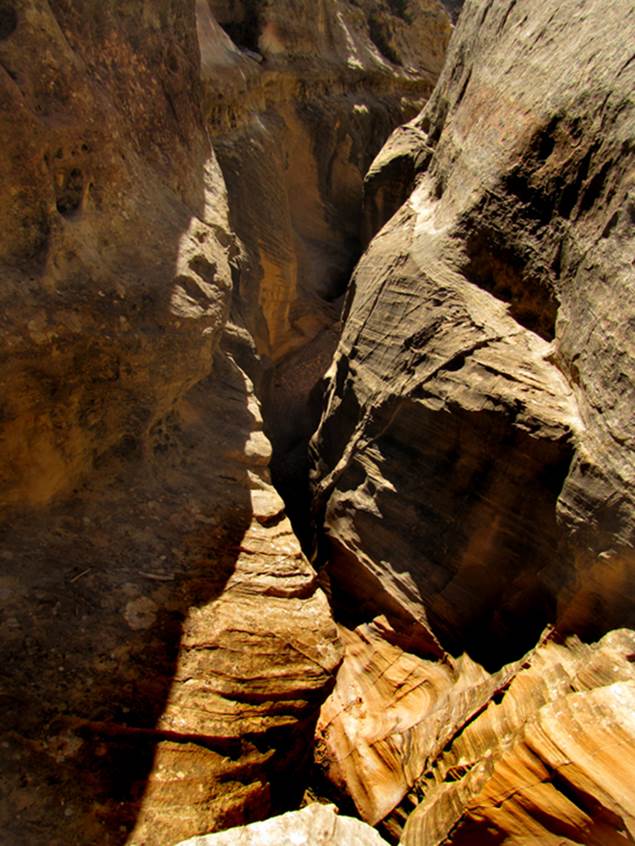
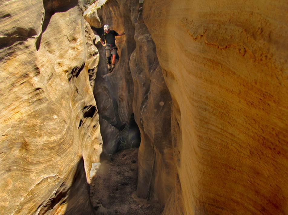
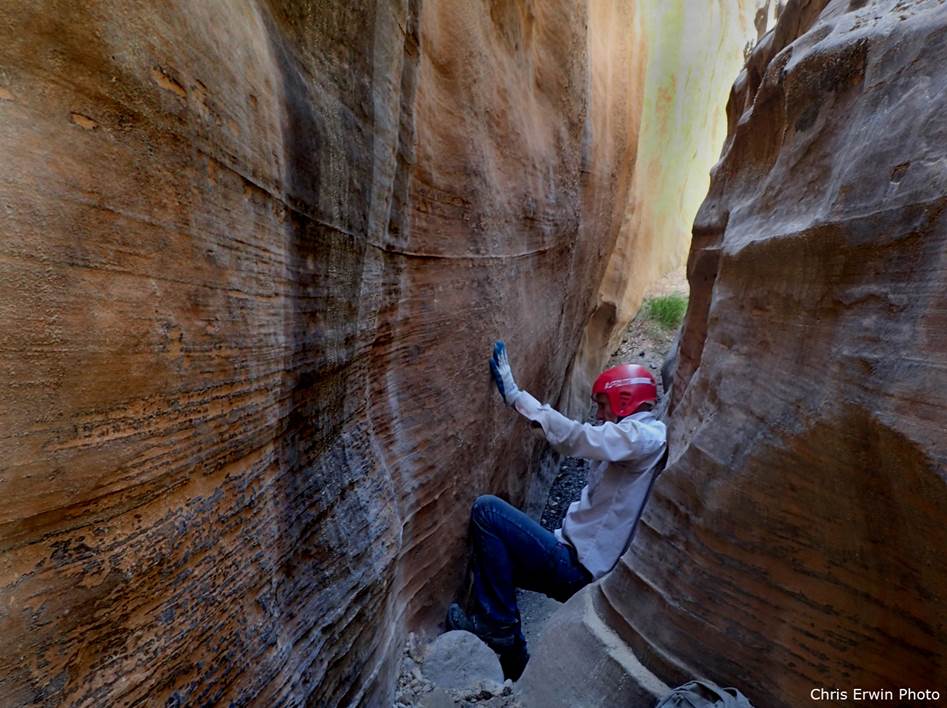
Above and below Chris Erwin enjoys the crux
of Cougar Slot Canyon
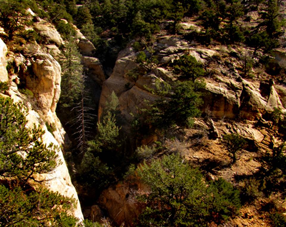
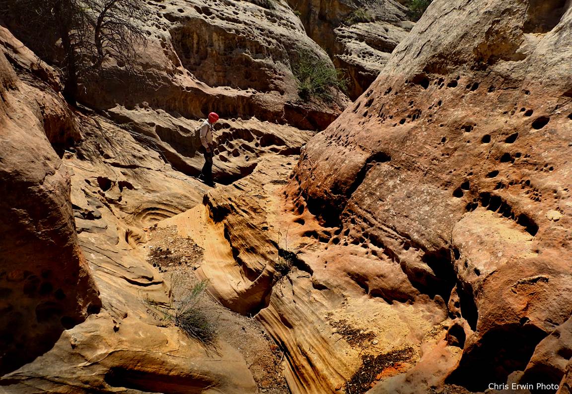
Below is the “Upper Tributary” near it’s
confluence with the main Cougar Canyon.
Entrada Sandstone and evergreens dominate these upper reaches...
The “Cougar” has an abundance of exciting
down-climbs ...as this 20’ drop shown below...
AND... even where the
canyon opens up briefly... it is beautiful...
beta facts:
name- Cougar Canon
first known descent- May 5, 2017 by Chris
Erwin and Doug Scott
depth of slot portion- sheer canyon walls of up to 70’ feet high
length of slot portion- almost 2 miles of
continuous sandstone narrows, including a couple tributaries
elevation- 7600’at the top down to 7100’at the bottom
GPS coordinates- ±36°20.430’N 106°48.550’W at the top and ±36°19.733’N 106°49.346’W at the lower end
flow- intermittent
season- late April into June plus September thru
early November… NEVER
ENTER ANY SLOT CANYON WHEN HEAVY RAIN IS IN THE FORCAST…!!!
accommodations- NONE
ownership- Santa Fe National Forest
access- is from Dry Lake 4WD Road off of Forest
Road #8… see the map below
nearest town- Gallina is
about 8 miles south of here
fun fact-
this canyon is extremely scenic…!!! ...and full of un-countable
and exciting rope-less down-climbs...! ! ! -with maybe 5 mandatory rappels.
essay bro
Most of the slot canyons in this area have
substantial sections of canyon walls that are 100% alabaster (gypsom).....and many of this area’s slot canyons are
entirely alabaster, with no sandstone.
Cougar Canyon Slot is all totally, beautiful - Entrada Sandstone...! ! !
Park
your wheels, south of Dry Lake: ±36°21.010’N
106°48.253’W ...and climb straight west up to the pass between the two
peaks: ±36°20.890’N 106°48.537’W From the peak south of the pass you can
either drop directly into Cougar Canyon- ±36°20.428’N
106°48.682’W ...or continue on south down the high ridge, into the upper end of
Cougar Canyon’s Upper Tributary- ±36°20.430’N 106°48.550’W ...or even continue
(south and southwest) along the high ridge, to the upper end of Cougar
Canyon’s Lower Tributary- ±36°19.915’N
106°48.941’W
Descending the Upper Tributary instead of the upper reaches
of Cougar Canyon is more beautiful, more active and some longer. We prefer the Upper Tributary to begin our
descent. All of your technical rope work
will be upstream from the Lower Tributary confluence. However Cougar Canyon Slot continues well
below this confluence. See the map
below.
Upon completing your descent of Cougar Canyon Slot there are
many way to return to your parked wheels.
The most exciting way is to ascend up the Lower Tributary... which will
take a full bag of tricks to do. It is a
shallow slot completely full of continuous rope-less up-climbs, extremely
steep, quite sculpted and very beautiful.
However, there will be 3 or 4 extremely challenging ascents. Like for instance, the first up-climb which
is about 100 yards above the confluence is a 9’ high, un-climbable
undercut. It must be done by slinging a
6 foot long etrier (connected to a hand-line) over
the chock stone that is suspended 9 feet high overhead. A meat anchor from below, enables the first
climber to ascend... who then can be a meat anchor from above as the others
ascend. The handline/etrier can be un-wrapped from around the chock stone after
everyone has ascended.
Farther up the lower Lower
Tributary there are more head-scratcher up-climbs... that are likely to be
unsurmountable by many - who will just have to return back down to Cougar
Canyon and walk one of the longer and less beautiful ways of returning to your
wheels. Perhaps the most difficult
up-climb is about mid-way. It starts in
a pothole, waste deep in cold clear water.
Our down-climb here was an unstoppable down-slide with a fun splash at the
bottom. This unstoppable down-slide must
be up-climbed. We do not know how to do
this because we have only down-climbed here... never up-climbed here... but we
believe it can be done and it will be extremely exciting... and we can’t wait
to get back in there to attempt it.
There are some dead standing snags that could be carried up to this
clear water pothole... to assist this up-climb... or perhaps some throw-bags
will hold a hand-line to assist an ascent here.
We are not sure but we believe that someone will make a way... and if
you accomplish this ascent before we do...then I hope we will be right behind
you.
If you cannot ascend this Lower tributary... then returning
to your wheels can be done via the high ridge (mentioned in the second
paragraph) between Cougar Canyon and Cañada de la
Cueva Norte or to do a loop-hike, down around, south of Cougar Canyon ...and
return to your vehicle via Cañada de la Cueva
Norte. Whatever way you choose will be a
long hard pull of about 3.5 miles via the high ridge and perhaps 4.5 miles or
more via Cañada de la Cueva Norte. We’ve done it both ways but this second
option is the route we have often taken.
Cougar Canyon Slot has a long return hike...... and..... this is
actually a good thing......as only the hearty visit Cougar Canyon Slot. It is a favorite of ours.
Cougar Slot Canyon has action... count-less
challenging down-climbs and maybe a half-dozen rappels, up to 30’ high… a sweet
favorite ! ! !
Cougar Slot Canyon
appears near the bottom of the map below
Click this link to open a
large detailed topo map of the entire slot canyon area near and within the western
Chama Canyon Wilderness: http://www.dougscottart.com/hobbies/SlotCanyons/Gallina.htm
Enhanced USGS topo map by Doug Scott
The Red Lines depict
sections of “slot canyons” AND the Yellow Dotted lines depict “routes”
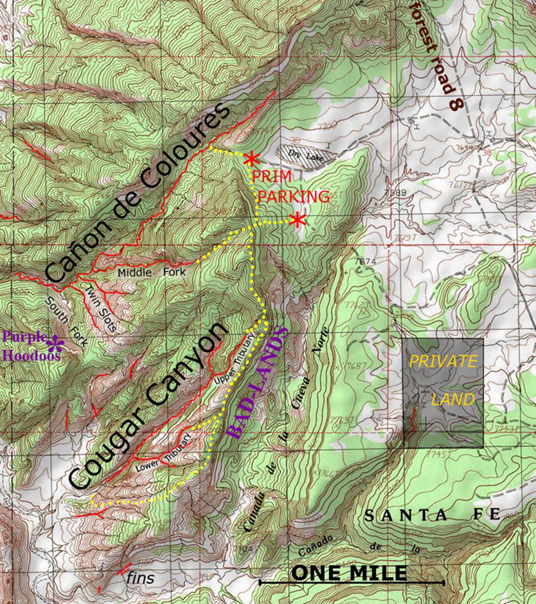
Click this link to open a
large detailed topo map of the entire slot canyon area near and within the
western Chama Canyon Wilderness: http://www.dougscottart.com/hobbies/SlotCanyons/CCWslotsMap.htm
Back to New Mexico
Slot Canyons
Send questions and comments to dscott@themarblesculptor.com