Wild
Boy Falls
Send me a photo…!!!
I have never been here…!!!
I wanna see it…..!!!!!!
beta facts:
name- Wild Boy Falls
height- 100’ high… so I have been told
elevation- 6000’
GPS coordinates- ±32°39.352’N 105°47.373’W
flow- Wild Boy Spring just above the falls
keeps a perennial trickle but summer rains and spring snow melt often creates a
sensational display of grandeur.
season- April of a wet winter year and
july/august of a rainy summer are the best.
accommodations- no trespassing
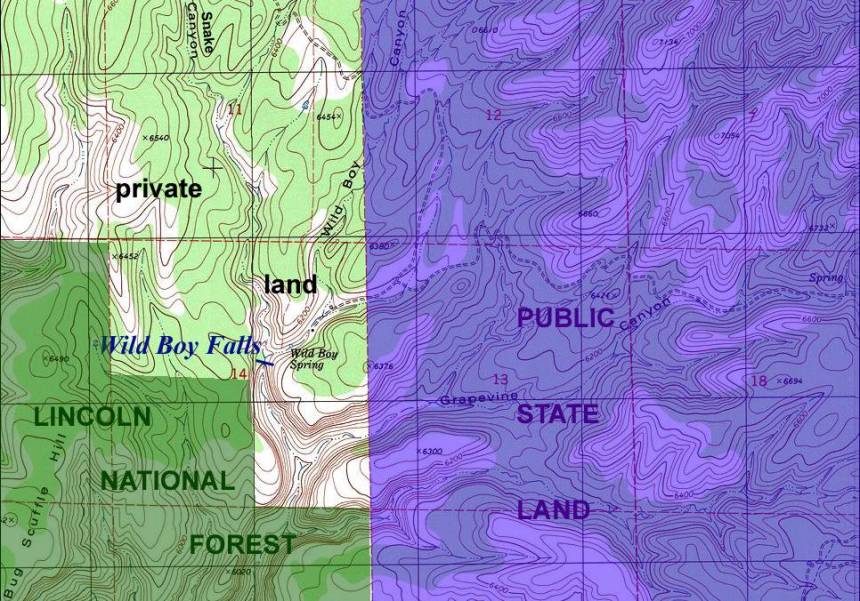
ownership- private subdivision… I believe
it’s called “Bug Scuffle”
access- a legal hike of 2 or 3 miles,
staying on public land, to a splendid vantage point viewing the falls from the
southwest… is hard …but quite do-able…!!!! The west-side canyon rim immediately below the waterfall is
Lincoln National forest land.
nearest town- an enormous subdivision
called “Timberon” is about 6 miles east of this falls.
fun fact- I’m akinda “wild boy”…I would
like to see “Wild Boy Falls”.
essay bro:
They tell me… that this is a fabulous
waterfall… especially when it is flowing big after a summer thunderstorm… and
they say, “it hangs with grapevines.”
…but look at those names on that map below…!!! WOW…!!! …Snake Canyon …Wild Boy Canyon …Wild Boy Spring and fall … and best of all… Bug Scuffle Hill …down in the lower left-hand corner of the map.
Happy waterfall hunting.
Enhanced National Geographic 7.5’ topo map
_____________one
mile_____________
Send questions and comments to doug.vivian@yahoo.com