Fillmore
Falls
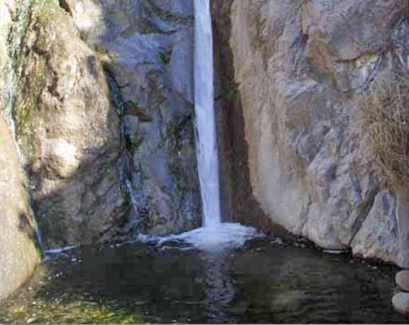
The Fillmore Canyon trail hikes right past this 40’ high
waterfall
beta facts:
name- Fillmore Falls
height- 40’
elevation-6250’
GPS coordinates- ±32°20.360’N 106°34.620’W
flow- perennial spring fed however during
winter and early spring it’s often big white and frothy
season- anytime
accommodations- day use picnic area and
museum no over-nite camping allowed
ownership- public - BLM
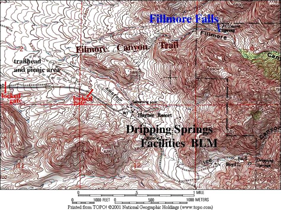
access- a mile and a half trail
nearest town- Las Cruses is 12 miles west
of here
fun fact- …ah …I can just feel more falls,
3 miles on up Fillmore Canyon below Rock House Spring
essay bro:
The feds have two gates at this
facility. One is extremely
reasonable… it protects the buildings and facilities. The other protects the trailhead. It is a shame that the bureaucracy closes and locks BOTH
gates from 5:00 PM to 8:00 AM.
This causes problems for both the rangers and the public. I feel sorry for the rangers because
they have to stay extra hours… probably without extra pay… just to get the
public cleared outa there at 5:00 PM… AND I do not like the inconvenience to us
the tax paying citizens. We can’t
hit the trailhead at dawn, which is really nice… AND we can not allow ourselves
to get carried away with our beautiful hike and stay till sundown, which is
also really nice.
When we hiked to the falls in March we were
late returning to the trailhead… and the ranger was understandably quite
irritated. He threatened to give
us a $200.00 fine and requested that we park out side the lower gate and walk
an extra mile or two on the paved road.
“Fine,” I Thought, “but this looks to me like a good place to get your
car vandalized… and there is NO PARKING PLACES AVAILABLE THERE….!!!!!!!!!” …and besides all that they would
probably have my rig towed and impounded AT MY EXPENCE…..!!!!!!!!!!!!!!
Why they can’t lock the upper gate to
protect the buildings and facilities while leaving the trailhead “UNLOCKED”… is
a marvel. It don’t take
“rocket-surgery” to realize the convenience of this option. Perhaps the feds love their authority
way too much to let go of even a tiny piece of it. They have given themselves the authority to shove you and I
into the tiny little box of their narrow-minded rules and they seem to love
inconveniencing themselves and us both….!!!!
Anyway it is not the waterfalls fault… so
enjoy it… and give a ranger a candybar.
Please copy and use our updated topo map
below. J
Enhanced
National Geographic 7.5’ topo map
Send questions and comments to doug.vivian@yahoo.com